
The Dictionary of Sydney was archived in 2021.
Gladesville

Citation
Persistent URL for this entry
To cite this entry in text
To cite this entry in a Wikipedia footnote citation
To cite this entry as a Wikipedia External link
Gladesville
Gladesville, situated on the northern banks of the Parramatta River approximately 10 kilometres from the city centre, adjoins the suburbs of Hunters Hill to the northeast, Boronia Park to the north, Ryde to the west and Tennyson Point to the southwest. Gladesville is divided between two local government areas – the City of Ryde (established in 1871) and the Municipality of Hunters Hill (established in 1861).
At the time of the arrival of Europeans at Sydney Cove in January 1788, the Wallumedegal or Wallumatagal were the traditional owners of the area, which they called Wallumetta. The earliest recorded contact was 20 days after the arrival of the First Fleet, when Captain Arthur Phillip and his Parramatta River exploration party landed, and named Looking Glass Bay after giving a looking glass (mirror) to an Aboriginal man they met there.
The first land grants
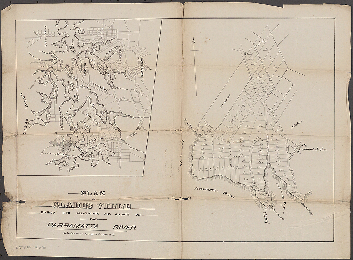
[media]European settlement began officially with land grants being made to John Doody, a convict artist, in 1795. Among others to receive grants in the district, which was then called Eastern Farms because it was east of Parramatta, were William House (1795), Ann Benson (1796) and William Raven (1799) [1]. At this time, the area was often called Doody's, but it was part of the Kissing Point district. In 1836 John Glade, an emancipist, was issued with the deeds to Doody's grant, which he had purchased in 1817.
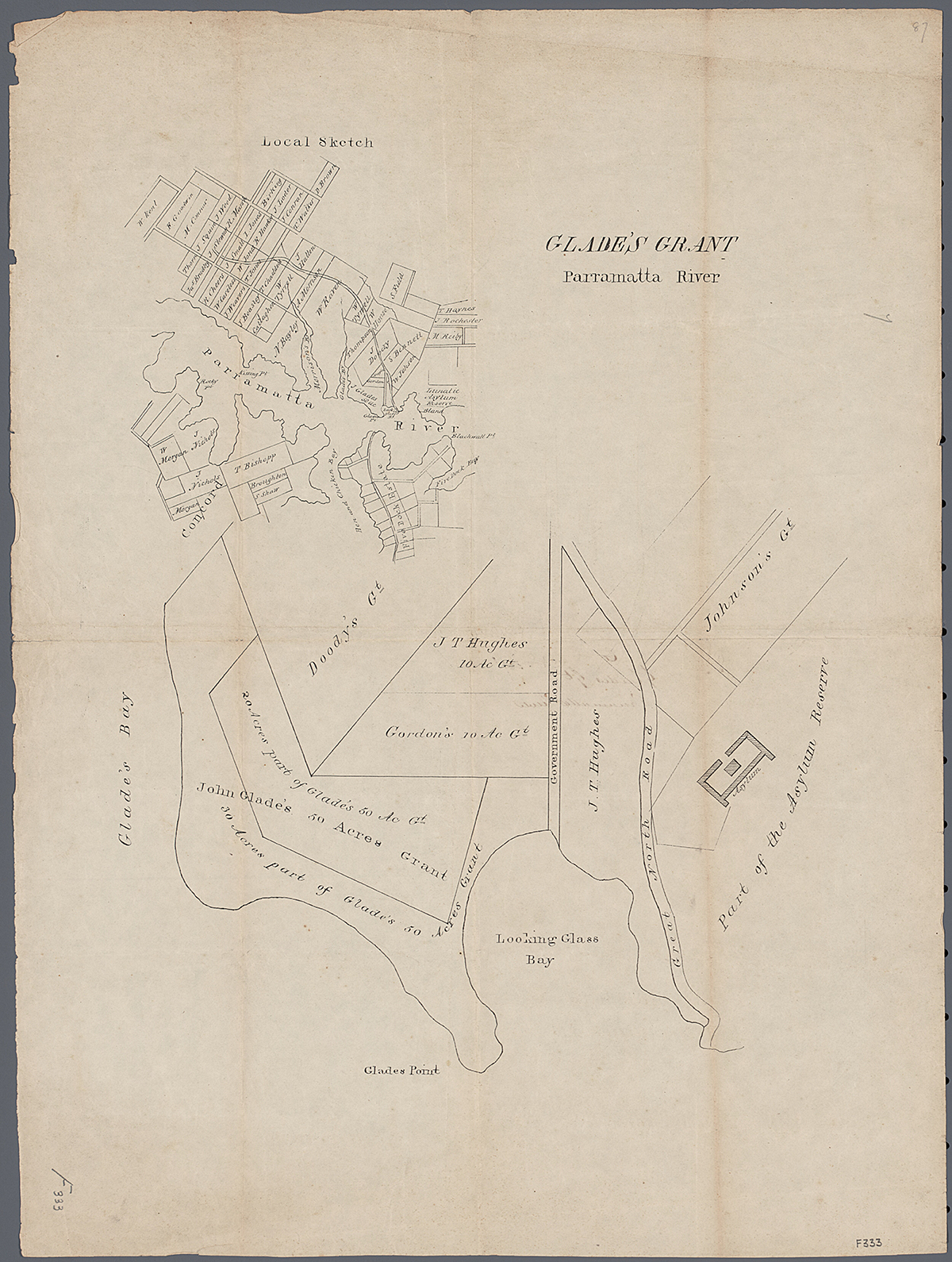
The district became a rural farming and dairy area supplying the Sydney market, but remained isolated, with the only access via the Parramatta River. By the time of John Glade's death in 1848, he had expanded his property to include a number of adjoining holdings. His land was sold to a Sydney solicitor, Mr W Billyard, who subsequently subdivided and sold the land in November 1855, naming it Gladesville.
In colonial times, a flagstaff was erected on the high point of a local ridge. It was an important communication point between Sydney and Parramatta, especially when the Governor was in residence at Parramatta. Signal flags relayed messages from Sydney to the next flagstaff near Brush Farm, and on to Parramatta.
Tarban Creek asylum
A defining aspect of the development of Gladesville was the building of the Great North Road (now Victoria Road). The road was surveyed in 1825 and led from the road between Sydney Town and Parramatta, down modern-day Great North Road at Abbotsford, across the Parramatta River by punt through Gladesville, along the ridge line through Ryde and then north to the Hunter Valley via Wisemans Ferry.
[media]The point at which the punt reached the northern shore of the Parramatta River was called Bedlam Point. The origins of this name are unclear. One can easily assume it was because of the nearby Tarban Creek Lunatic Asylum, designed by Mortimer Lewis and opened in 1838. Bedlam was a corruption of Bethlem/Bethlehem, the name of England's first lunatic asylum. However, the name Bethlem was applied to the area as early as 1820 and it was officially called Bedlam Point soon afterwards, long before the Tarban Creek asylum was built.

With the opening of the asylum, the first patients were transferred from Liverpool Asylum and the Female Factory at Parramatta. It also accepted patients from the southern part of the colony (later Victoria) up until 1848, when the Yarra Bend asylum was opened. In 1869, Tarban Creek Lunatic Asylum was renamed Gladesville Hospital for the Insane. By the mid-1960s, the institution was known simply as Gladesville Hospital. In 1993 premises at Gladesville Hospital and Macquarie Hospital were revoked as hospitals, and were amalgamated to form the Gladesville Macquarie Hospital. Today, much of the hospital's riverfront grounds forms part of the Parramatta River Recreation Park.
Crossing the river
The subdivision and development of the Gladesville estate included the building of a wharf at the bottom of Wharf Road. This was to allow better access to the area and overcome the difficult task for passengers of alighting midstream from the regular Parramatta River steamers onto the punt to be conveyed to shore. The land parcels were described as suitable sites for 'gentlemen's villas' with ample grounds for gardens, lawns and orchards. A post office was established at the wharf from 1861. The regular ferry services, bringing residents and visitors, led to a decline in the use of the punt after the 1860s.
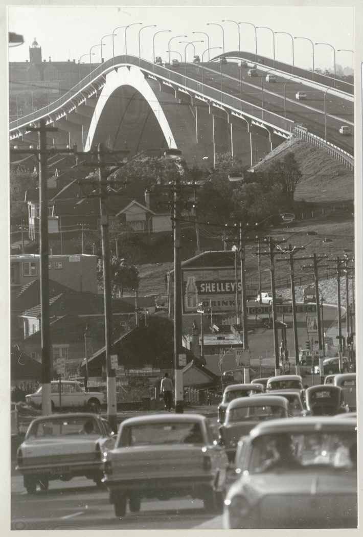
[media]From 1861 residents of the wider district began petitioning for better access to the area. The final result was the resumption and subsequent sale of parts of the Field of Mars Common. The money raised was used to finance the construction of the Gladesville and Iron Cove bridges, providing a direct road access to Sydney. The first Gladesville Bridge opened in 1881. It was replaced by the present concrete-arch bridge in 1964.
After the opening of Gladesville Bridge in 1881, horse-drawn bus services operated to the city and provided an alternative to ferry transport. In 1910 the tramline from the city to Drummoyne was extended across the Gladesville Bridge through to Gladesville and eventually to Ryde. This fast and efficient transport service was the impetus for many subsequent residential subdivisions along the Great North Road, later Victoria Road.
Rockend
One early buyer of land at Gladesville was a Limerick-born master builder named John Crotty. He bought a block of land just above the Bedlam punt and proceeded to erect a 'substantial stone-built family residence, containing seven rooms and kitchen' which later acquired the name Rockend. Crotty also bought several blocks of land on the Great North Road near the flagstaff, and built a weatherboard cottage there, which by 1864 had become the Gladesville Hotel, supplying the needs of travellers. Gladesville's first hotel, the Flagstaff Inn, had been licensed to John Worthington in 1856.
Rockend has its own unique history – from 1866 to 1909 it was home to Emily Mary Barton, the grandmother of poet AB (Banjo) Paterson. In 1923 it became the office of Harold Meggitt's Halmeg factory, which produced linseed oil products. By the 1970s the factory had left the site and the cottage was empty and vandalised. Community lobbying, led by the Gladesville Progress Association, eventually succeeded in persuading the state government and Ryde council to purchase the 5.2-acre (2-hectare) site. By 1986, Rockend cottage had been restored and the adjoining Banjo Patterson Park created.
The village of Gladesville emerges
[media]The Bedlam Point settlement, which had begun around the junction of Wharf and Great North roads and grown westward, emerged as the distinct village of Gladesville by the 1870s. The post office moved from the wharf to this area in 1867. Sydney's first Protestant hall was built in Gladesville in 1867, allowing different itinerant ministers to conduct services in the area. The Anglican Christ Church opened in 1877 and became a separate parish in 1878. Gladesville Public School began classes in April 1879. In 1888 the Presbyterian Church of St Andrew was built.
River regattas
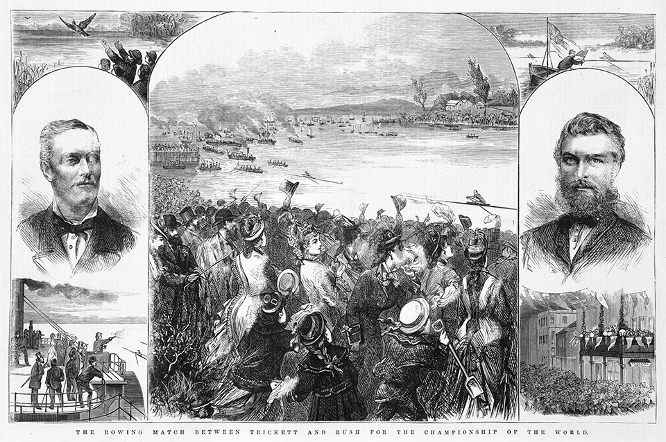
[media]From the 1850s, regular regattas were held on the Parramatta River, making the river and its surrounding districts the venue for major rowing events. Soon a championship rowing course was defined, beginning at Charity Point near Isaac Shepherd's house Helenie (at modern-day Meadowbank) and finishing at a group of three rocks called The Brothers at Henley. The real heyday of the river as a sporting venue began in 1877, when the first contest to be held in Australia for the title of Champion Sculler of the World was held here. The Illustrated Sydney News estimated that between 60,000 and 70,000 people witnessed the race. Many of these visitors and those associated with these races visited and stayed in Gladesville and surrounding areas.
War memorials
Gladesville has a number of significant World War I memorials. The Christ Church memorial gates consist of four ecclesiastical-style stone gate pillars with central double iron gates and a single gate each side. Commemorative metal plaques contain the names of 167 servicemen from the Gladesville area. The memorial gates, on the corner of Victoria Road and Jordan Street, were officially unveiled by the governor-general, Lord Stonehaven, in 1926. They were moved to their present location during the widening of Victoria Road. From their installation they were the focus of local Returned and Services League (RSL) and ecumenical community Anzac Day services until the end of the twentieth century, when safety and traffic issues moved these ceremonies to the Peace Garden within the Gladesville Public School grounds. The Presbyterian Church of St Andrew, located diagonally opposite Christ Church, also has a 1914–18 honour roll on the exterior of the building. Its plaque contains 67 names. Only six names appear on both plaques. Gladesville's Catholic Church was also built as a war memorial. Completed in 1925, it was dedicated to Our Lady Queen of Peace.
Black Lucy
A well-known Gladesville identity of the 1920s was simply known as Black Lucy. She was Lucy Willerri, an Aboriginal woman, originally from Alligator River in Queensland, and she was aged somewhere between 70 and 100. Along with her dogs, she made her home in a humpy of scrap iron and wood in the lantana and blackberry bushes on the banks of Tarban Creek. When her hut burnt down in 1923, the citizens of Gladesville were so concerned they organised and built a new cottage for her in Auburn Street. More then 200 people attended the ceremonial handing over of keys by the Mayor of Hunters Hill. When Lucy died in 1928, she was buried in the Presbyterian section of Field of Mars Cemetery, and the costs were met by the residents of Gladesville.
Ryde Housing Scheme
The Ryde Housing Scheme was one of the most innovative post-World War II housing schemes operating in the municipality of Ryde. The housing shortage that existed before the war had worsened during the war because of building restrictions. At the end of the war, as ex-servicemen and women were demobilised, marriage rates increased and so did the need for houses. With federal funding, the New South Wales Housing Commission embarked on a large-scale program of welfare housing. However, Ryde Council wanted more than welfare housing. The proposed scheme offered would-be home owners the option of buying houses with small deposits at a low rate of interest, with repayments over a long period.
The scheme, distinguished also by its employment of a panel of ten architects and town planners who were leaders in their fields, provided for the erection by council of 2,500 homes over a five-year period. Each subdivision boasted bitumen-surfaced roads, kerbing and channelling, footpath paving, street beautification and general drainage. Not only was each subdivision planned with attention to the natural contours of the land, but roads were designed to reduce traffic speeds and provide a maximum of safety to residents within the area. The planning of the subdivision was linked with the planning of each house in its own garden setting.
Between 1945 and 1952, 599 houses were built by council and a further 360 were built under a Ryde loan scheme. Eighteen project areas were planned, but political opposition blocked their full implementation. Seven project areas were completed, with the largest comprising 173 homes in Denistone. Two project areas were located within Gladesville. Project number three was built on land which had been part of the former Gladesville soccer ground and included Pelican, Swan, Halcyon and Gannet streets and part of Thompson Street, Gladesville. Project number ten was on land previously occupied by Peel's dairy in Gladesville. Mr JF Peel offered the land to council for the scheme on condition that 50 of the lots should be reserved for ballot by ex-servicemen and women. Streets in this project include Brereton, Osgathorpe, Towns and Stanbury, with 153 houses erected.
Meriton Street in Gladesville is the inspiration for the naming of Harry Triguboff's Meriton Apartments empire: in the 1960s, he built his first block of units in Meriton Street in Gladesville.
References
Megan Martin, A pictorial history of Ryde, Kingsclear Books, Alexandria NSW, 1998
Alex McAndrew, Glimpses of Gladesville: past and present, the author, Epping NSW, 2004
Gregory Blaxell, The river, Brush Farm Historical Society, Eastwood NSW, 2004