
The Dictionary of Sydney was archived in 2021.
The Rocks

Citation
Persistent URL for this entry
To cite this entry in text
To cite this entry in a Wikipedia footnote citation
To cite this entry as a Wikipedia External link
The Rocks
The Rocks is the historic neighbourhood on the western side of Sydney Cove. It rises steeply behind George Street and the shores of west Circular Quay to the heights of Observatory Hill. It was named The Rocks by convicts who made homes there from 1788, but has a much older name, Tallawoladah, given by the first owners of this country, the Cadigal people. Tallawoladah, the rocky headland of Warrane (Sydney Cove), had massive outcrops of rugged sandstone, and was covered with dry sclerophyll forest of pink-trunked angophora, blackbutt, red bloodwood and Sydney peppermint. The Cadigal probably burnt the bushland here to keep the country open. Archaeological evidence shows that they lit cooking fires high on the slopes, and shared meals of barbecued fish and shellfish. Perhaps they used the highest places for ceremonies and rituals. Down below, Cadigal women fished the waters of Warrane in bark canoes. [1]
The convicts' side of town
After the arrival of the First Fleet in 1788, Tallawoladah became the convicts' side of the town. While the governor and civil personnel lived on the more orderly eastern slopes of the Tank Stream, convict women and men appropriated land on the west. Some had leases, but most did not. They built traditional vernacular houses, first of wattle and daub, with thatched roofs, later of weatherboards or rubble stone, roofed with timber shingles. They fenced off gardens and yards, established trades and businesses, built bread ovens and forges, opened shops and pubs, and raised families. They took in lodgers – the newly arrived convicts – who slept in kitchens and skillions. Some emancipists also had convict servants. After November 1790, large numbers of Aboriginal people came into the town to visit and to live, and apparently continued to live there over the nineteenth and twentieth centuries. [2]
Orderly, grid-patterned streets were impossible on the rugged terrain of The Rocks, and people moved about mainly on foot, so a web of footpaths led along and up the shelving ledges and from door to door. By 1805, the area had a stone church, St Philip's, at the southern periphery on Church Hill (now Lang Park), and several windmills creaked on the western horizon above. At the foot of The Rocks, in what later became George Street, stood the walled jail and the town's first hospital. Clustered at the water's edge opposite were public and private wharves, and the storehouses and elegant mansions of the early Sydney traders, fast growing rich in the nascent port town. Perhaps best known of these was the merchant Robert Campbell, who built his wharf and warehouses and an Indian-style bungalow on Campbell's Cove. [3]
[media]For convict women in particular, The Rocks above could be a place of opportunity, where they got their start in trade, buildings and land. The dynamic Mary Reibey, who arrived as a convict in 1791, started out from a small house in The Rocks, amassed a fortune from trade and shipping, built a number of fine houses in Sydney and raised a large family. [4]

Surrounded by water on three sides, The Rocks was associated with seafaring, waterside workers and the maritime trades for most of its history. It was the link with the wider world, a place of new ideas, things and people, with sailors from all over the world on shore leave, and with the constant movement of people and goods through the port. While Governor Macquarie had straightened the other streets of Sydney during the 1810s, those of The Rocks remained crooked and uneven. It also remained a convicts' place, for when the men from Hyde Park Barracks (opened in 1819) were allowed out on Sundays after church 'they run immediately to that part of the town they call the Rocks where every species of Debauchery and villainy is practiced'. [5]
Expansion and consolidation
[media]By 1823, about 1,200 people lived in The Rocks, most of them emancipists and convicts and their children. The 1820s and 1830s were marked by the expansion and consolidation of trade, as the houses, stores and wharves of merchants and ship-owners expanded right around Dawes Point to Millers Point and Cockle Bay (now Darling Harbour). [6] A substantial stone bond store, built from 1826 in Argyle Street, served as the first Customs House, and still stands as part of the Argyle Stores. The buildings on the surrounding slopes ranged from substantial two-storey residences, shops and hotels to small rental tenements of one or two rooms. Nearby, massive quarries around Observatory Hill supplied stone for building and left behind sheer cliff faces.
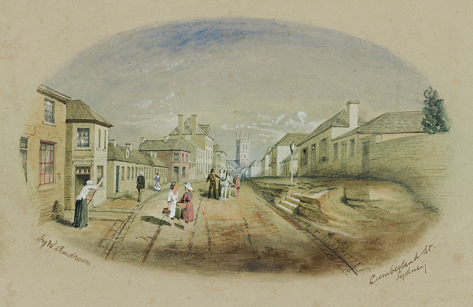
[media]At the newly developing northern ends around Bunkers Hill, and on the heights of Cumberland and Princes streets, wealthy middle-class people built elegant and fashionable mansions and town houses.

After the end of transportation in 1840 and with the discovery of gold in 1851, immigration to the colony rose dramatically, resulting in an intense demand for housing. The Rocks became a place where immigrant people found their first foothold, squeezed into existing houses and even converted stables.
Developers and residents began subdividing the large old yards and built rows of small, plain terrace housing; the older houses often remained standing at the rear. This was a landscape of rapid urban growth: close-packed, at first ill-serviced, with a multiplying maze of lanes and blind courts, and severe problems of water supply, rubbish and sewage disposal.
Although piecemeal street-making, paving and drainage works were carried out constantly from the 1850s, progress seems to have been slow and the results quickly worn down or blocked up. Sewer lines were installed down the main streets in the 1850s, but not every house was connected. Many houses had stone cesspits, and some had nothing at all. [7]
Labour and funding could be found for works that assisted private enterprise, however. In 1843, convict gangs were put to work on a cut right through the ridge at the heart of The Rocks, extending Argyle Street to connect Sydney Cove with the booming area of Darling Harbour. Earlier, drays and people had to take the long way round, north or south. The rubble stone from the Argyle Cut was carted away to build an even larger project: the first stage of Circular Quay. But work was slow, and when the convict labour force dwindled, the Argyle Cut project stopped. It was eventually completed, using paid labour and gunpowder, in 1859. Bridges reconnected the severed streets above in the 1860s.
Sydney's 'other' place
The area had been home to people of widely divergent classes over the nineteenth century – from the rich in their impressive houses on the ridges, through ship captains and shopkeepers, to labourers and the drifting poor. But after the 1870s, this profile began to change as the wealthy increasingly abandoned city neighbourhoods for homes in the new suburbs.
The Rocks became an increasingly working-class area. It had also been a place of fearful fascination for outsiders – it was always Sydney's 'other' place. Its proximity and links with the waterside gave it exotic and threatening sounds, smells and sights. Among its population were relatively high numbers of immigrant peoples, including Irish and Chinese. Lower George Street, at the foot of The Rocks, became Sydney's first Chinatown. [8] The area hosted seamen from all over the world, some of whom took a liking to the place, married local women and settled there. Its culture was that of urban working people: drinking, pubs, gambling and sport dominated. Its distinctive rocky and steep topography and the increasingly old-fashioned, cheek-by-jowl houses were familiar and comfortable to local residents, but they made journalists and philanthropists, and their readers, feel ill at ease.
The Rocks was old Sydney, associated with the shadowy, shameful convict past. It seemed increasingly out of kilter with the self-consciously modernising city. Even that great improvement, the Argyle Cut, looked increasingly dark and menacing as the decades passed. [9]
Archaeology rewrites the story of The Rocks
[media]Yet the view from inside the houses is rather different. Archaeological digs at The Rocks have allowed a rare window onto the living conditions for the people who lived there – coal lumpers, sailors, dressmakers, housewives, small shopkeepers, labourers, tradesmen and tradeswomen, and lots of children. The archaeologists recovered tea sets and dinner sets, silver-plated cutlery, washbasins and ewers, jewellery and watch pieces, buttons, beads and buckles, children's toys, figurines and thousands of other things. Together they speak not of a filthy slum, but of people who were of modest means, or poor, striving under often difficult circumstances for domestic comfort, a measure of cleanliness, personal care and appearance, and the education and care of children. [10]

The arrival of the plague and the resumption of The Rocks
When the first epidemic of bubonic plague broke out in Sydney in 1900, all eyes turned to the old working-class waterfront neighbourhoods. The Rocks in particular was seen as the source of contagion. The disease was carried by fleas on the rats which came ashore from ships, so people who worked in these areas were particularly vulnerable, and they bore the brunt of the disease. However, the plague affected many other parts of Sydney too, and of the 303 victims of the plague, only five were from The Rocks. Ironically there had been great improvements in urban conditions and amenities the decade before, and the infant mortality rate in the city wards had already dropped considerably. [11]
Nevertheless the plague was a catalyst for the next major development in the area's history: the state government resumed the whole of the area around Darling Harbour in 1900 and the residents became public tenants. Over the next 20 years, the entire waterfront was demolished and rebuilt. In the residential areas, hundreds of houses were demolished, so accommodation became still harder to find for waterside workers' families who had to live near the wharves. Neighbouring Millers Point was rebuilt with extensive public housing (some of the earliest examples in the world), although in The Rocks the number of new houses fell far short of what had been destroyed. It was hoped that industry and commerce would eventually sweep away the old houses and streets, and over the early twentieth century large factories and stores did appear. Bushell's tea factory in Harrington Street, the State Clothing Factory and the Metcalfe Bond Stores, which still line George Street north, replaced earlier buildings but also provided work for local people.
From 1900, too, The Rocks was repeatedly scored and scarred. Whole streets of houses were demolished to make way for straighter street realignments, for wharf developments, for the Harbour Bridge approach in the 1920s and early 1930s, and for the Cahill Expressway in the 1960s. [12]
But the local community did not disappear. Residents became the tenants of successive state government bodies – the Sydney Harbour Trust, the Maritime Services Board and finally the Sydney Cove Redevelopment Authority. This fostered the community, for it gave people security of tenure and fixed rents for the first time. Instead of moving about every two years, as they had done in the nineteenth century, families stayed in one house over many years, even passing leases onto their children.
[media]In some streets, such as Atherden Street, children grew up surrounded by grandparents, aunts and uncles. People felt they belonged in these houses and in The Rocks; this sense of place would have important outcomes. The completion of the Harbour Bridge also meant that The Rocks was bypassed by traffic and trade, and became a sort of forgotten enclave. The rate of local intermarriage seems to have been high, and most Rocks people recall that everyone really did know everyone. [13]

The Rocks was a hardy perennial in the newspapers over the twentieth century, appearing in a succession of grand schemes dreamed up by planners and government departments, all of which involved complete demolition and redevelopment, and none of which eventuated. There were also nostalgic pieces which dwelt on the age and history of the neighbourhood, usually set in the context of imminent, inevitable change. Artists of the Old Sydney School sketched, painted and photographed the picturesque lanes and terrace houses, so different from the modern suburbs that were spreading all around the city. By the early 1960s, curious tourists had begun to explore the old urban spaces. But to governments The Rocks was a blot on the pride of the modern city, its terrace houses bore the stigma of slum buildings, its people were considered slum dwellers. In December 1960 the state government advertised the whole area for sale in the New York Times; apparently there were no takers. [14]
The Battle of The Rocks
In 1970, The Rocks was placed under the control of a new semi-autonomous body, the Sydney Cove Redevelopment Authority, headed by Colonel DO McGee. Colonel McGee was charged with the efficient relocation of residents, often to outer-western Sydney, and with redeveloping the area as a high-rise commercial precinct.
But by this stage many local people did not want to move, nor did they want The Rocks destroyed. The Rocks Residents Action Group, led by the determined and eloquent Nita McCrae, protested and lobbied, but when this proved ineffective, it asked the Builders Labourers Federation to help by placing a green ban on the area. Between 1971 and 1974 the green bans resulted in a bitter and often violent struggle which became known as the Battle of The Rocks. The aim of the green bans was to preserve the built fabric of the place, but also to maintain the community and keep a place for working people in the city. In doing this the residents, protesters and unionists were challenging the right of politicians and planners alone to shape the future of the city. [15]
They were successful in defending the historic fabric from the wrecker's ball and bulldozer, but The Rocks had to pay its way, and so rather than remaining a working-class neighbourhood, it was developed by the Sydney Cove Redevelopment Authority as a historic attraction for tourists. As the local population aged and passed away, houses became shops, cafes and galleries. The old Argyle Bond Stores had already been converted to the Argyle Arts Centre, with its heady scents of handcrafted leather, soap and candles. After nearly 200 years of official suppression, the name was finally embraced in 1974 and listed with the Geographical Names Board as The Rocks. Publicity campaigns promoted tourism with the famous slogan: 'The Rocks: Birthplace of a Nation'. [16]
Although historically dubious, this phrase caught the wave of burgeoning public interest in Australian history, genealogy and heritage. The Rocks was now national heritage, and so every Australian, not just that small number of local residents, had a stake in the place. [17] One ironic outcome of the Battle of The Rocks is that today only a handful of people live in the area, but more than 9 million people visit it every year. Most are tourists and daytrippers who come to shop, eat and stroll, but some are pilgrims, with deeply-felt links to the place. They visit childhood homes or the sites where their forebears lived.
The Rocks today
The main activities in The Rocks today are commercial development, marketing and tourism, and it is derided by critics as a 'heritage theme park', empty of meaning. But its present manager, the Sydney Harbour Foreshore Authority, has also fostered important work in heritage restoration, archaeological research and some sensitive and thoughtful historical interpretations.
For example, tucked away behind the Argyle Stores, Foundation Park features the archaeological remains of terrace houses, set with artwork representing domestic furniture: table and chairs, dresser, clock, a washtub. It is a quiet, reflective oasis where visitors may recall the lost generations. People are drawn to the historic appearance and ambience of The Rocks, for this once-common townscape is now so rare. There is that fascinating sense of the past existing in the present that Ruth Park wrote about so well in her novel Playing Beatie Bow. [18] The remaining Victorian and Edwardian buildings – houses, warehouses, pubs, shops, a few factories – jostle gloriously in the topographical drama of steep steps and lanes linking the never-quite-straightened streets. Here is a bit of Sydney that miraculously escaped both high-rise and grid, a place where it is still best to move about on foot.
References
Grace Karskens, The Rocks: Life in Early Sydney, Melbourne University Press, 1997
Grace Karskens, Inside the Rocks: The Archaeology of a Neighbourhood¸ Hale & Iremonger, Sydney, 1999
George Morgan, 'History on the Rocks', in John Rickard and Peter Spearritt (eds), Packaging the Past? Public Histories, Melbourne University Press, Carlton, 1991
Notes
[1] Val Attenbrow, Doug Benson and Jocelyn Howell, Taken for Granted: The Bushland of Sydney and its Suburbs, Kangaroo Press and Royal Botanic Gardens, Sydney, 1995, pp 42–3
[2] Grace Karskens, The Rocks: Life in Early Sydney, Melbourne University Press, 1997; Inge Clendinnen, Dancing With Strangers, Melbourne, Text Publishing, 2003, p 133
[3] Margaret Steven, 'Campbell, Robert (1769–1846)', Australian Dictionary of Biography, vol 1, Melbourne University Press, 1966, pp 202–6; Margaret Steven, Merchant Campbell 1769–1846: A Study in Colonial Trade, Oxford University Press, Melbourne, 1965; Joan Kerr and Hugh Falkus, From Sydney Cove to Duntroon: A Family Album of Early Life in Australia, Victor Gollancz Ltd, London, 1982
[4] G.P Walsh, 'Reibey, Mary (1777–1855)', Australian Dictionary of Biography, vol 2, Melbourne University Press, 1967, pp 373–74; Nance Irvine, Mary Reibey, Molly Incognita, Emancipist Extraordinaire, Library of Australian History, Sydney, 1982
[5] Grace Karskens, The Rocks: Life in Early Sydney, Melbourne University Press, 1997, pp 34, 167
[6] Grace Karskens, Inside the Rocks: The Archaeology of a Neighbourhood¸ Hale & Iremonger, Sydney, 1999, pp 124–30; Shirley Fitzgerald and Christopher Keating, Millers Point: The Urban Village, Hale & Iremonger, Sydney, 1991, ch 1
[7] Max Kelly, 'Picturesque and pestilential: the Sydney slum observed 1860–1900' in Max Kelly (ed), Nineteenth Century Sydney: Essays in Urban History, Sydney University Press, Sydney, 1978, pp 66–80; Grace Karskens, Inside the Rocks: The Archaeology of a Neighbourhood¸ Hale & Iremonger, Sydney, 1999, ch 3
[8] Wayne Mullens, 'Just Who are the People in Your Neighbourhood? The Archaeology of "the Neighbourhood' in the Rocks and Millers Point"', BA thesis, University of Sydney, 1993; Shirley Fitzgerald, Red Tape, Gold Scissors: The Story of Sydney's Chinese, State Library of New South Wales Press, Sydney, 1996, pp 67–8; Jane Lydon, Many Inventions: Historical Archaeology and the Chinese in the Rocks, Sydney, 1890–1930, Monash Publications in History, Melbourne, 1999
[9] Grace Karskens, Inside the Rocks: The Archaeology of a Neighbourhood¸ Hale & Iremonger, Sydney, 1999, ch 6; Grace Karskens, 'Small Things, Big Pictures: New Perspectives from the Archaeology of Sydney's Rocks Neighbourhood', in Alan Mayne and Tim Murray (eds), The Archaeology of Urban Landscapes: Explorations in Slumland, Cambridge University Press, Cambridge, 2002, pp 69–85
[10] Grace Karskens, Inside the Rocks: The Archaeology of a Neighbourhood¸ Hale & Iremonger, Sydney, 1999
[11] Grace Karskens, Inside the Rocks: The Archaeology of a Neighbourhood¸ Hale & Iremonger, Sydney, 1999, pp 89–90; Peter Curson and Kevin McCracken, Plague in Sydney: The Anatomy of an Epidemic, University of New South Wales Press, Sydney, nd; Plague Registers, State Records of New South Wales, X647; Shirley Fitzgerald, Rising Damp: Sydney 1870–1890, Oxford University Press, Melbourne, 1987, pp 99–100
[12] Grace Karskens, Inside the Rocks: The Archaeology of a Neighbourhood¸ Hale & Iremonger, Sydney, 1999, pp 186–98; S Fitzgerald and C Keating, Millers Point: The Urban Village, Hale & Iremonger, Sydney, 1991, pp 65–122; Christopher Keane, 'Darling Harbour to Daceyville: The Housing Reform Movement in Sydney 1900–1915', PhD thesis, University of Sydney, 1996
[13] Grace Karskens, 'Tourists and Pilgrims: (Re)visiting the Rocks', Journal of Australian Studies, January 2003, pp 29–38
[14] Sydney Morning Herald, 12 December 1960
[15] Peter Manning and Marian Hardman, Green Bans: The Story of an Australian Phenomenon, Australian Conservation Foundation Publications, Melbourne, c1984; Meredith Burgmann and Verity Burgmann, Green Bans, Red Union: Environmental Activism and the NSW Builders Labourers' Federation, University of New South Wales Press, Sydney, 1998; Pat Fiske, Rocking the Foundations: A History of the NSW Builders Labourers Federation 1947–1974, video recording, Bower Bird Films, 1975
[16] George Morgan, 'History on the Rocks', in John Rickard and Peter Spearritt (eds), Packaging the Past? Public Histories, Melbourne University Press, Carlton, 1991 and Australian Historical Studies, 1991, pp 78–87; AW Johnson, 'Showdown in the Pacific: A Remote Response to European Power Struggles in the Pacific, Dawes Point Battery Sydney 1791–1925', in Historical Archaeology, vol 37, no 1, 2003, pp 114–127
[17] George Morgan, 'History on the Rocks', in John Rickard and Peter Spearritt (eds), Packaging the Past? Public Histories, Melbourne University Press, Carlton, 1991
[18] Ruth Park, Playing Beatie Bow, Penguin, Melbourne, 1988